

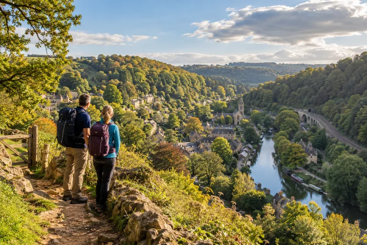
A walking day around Limpley Stoke does not need to be complicated to feel memorable.
The village sits in one of the most attractive sections of the Avon Valley, where wooded hills, limestone houses, old churches, riverside paths, railway lines, and the Kennet & Avon Canal are packed into a surprisingly small area.
The key to planning a good day is balance. You want enough distance to experience the countryside properly, but not so much that you rush past the historic details that make the area interesting.
Knowing how to plan a scenic walking day around Limpley Stoke Village also means choosing between very different kinds of terrain.
Higher paths around Limpley Stoke and Freshford can be steep and muddy, while the nearby canal towpath offers a gentler alternative. Public transport adds even more flexibility, especially if you want to finish at Freshford, Avoncliff, or Bradford-on-Avon instead of walking back.
With a little preparation, you can combine heritage, views, water, countryside, and a relaxed lunch stop into one easy day.
Start Early and Give Yourself More Time Than the Distance Suggests
Limpley Stoke is best enjoyed without a strict hiking pace.
A route of only five or six miles can easily fill most of a day if you stop at churches, viewpoints, aqueducts, cafés, and riverside spots. That is part of the appeal.
Starting between roughly 9:00 and 10:00 in the morning gives you plenty of daylight without requiring a very early departure. In warmer months, an earlier start also lets you complete steeper sections before the middle of the day.
Do not judge the route only by mileage. The official Two Church Circular between Freshford and Limpley Stoke is just 2 miles, or 3.22 kilometres, but includes around 95 metres of ascent and descent, unsurfaced paths, and steep sections.
That means walking time can vary considerably depending on conditions, photography stops, and fitness.
Begin With the Historic Lanes of Limpley Stoke
Starting inside the village gives the day some historical context before you head into open countryside.
Limpley Stoke rises westward from the River Avon, while woodland occupies sections of the higher valley. Wiltshire’s local history records show that the settlement has Saxon roots and that the original community once stood around the present St Mary’s Church area.
The church is therefore a useful first landmark.
Walk slowly through the surrounding lanes and pay attention to the limestone buildings, stone walls, rooflines, and steep changes in elevation. The village’s layout makes much more sense when experienced on foot than when driving through it.
This is also a good point to appreciate how the valley shaped settlement. Homes were built on rising ground, while industry and later transportation developed closer to the river.
Allow around 30–45 minutes for wandering before committing to the longer countryside section.
Use the Two Church Circular as Your Morning Walk
For a manageable morning route, connect Limpley Stoke with nearby Freshford.
The Two Church Circular is one of the easiest established walks to build into a day plan. It links St Mary’s at Limpley Stoke with St Peter’s Church in Freshford and combines village streets, field paths, woodland, the River Frome, and valley views.
The route takes about an hour according to Cotswolds National Landscape, although a relaxed walker should allow longer.
One particularly scenic section runs around Crowe Lane and Crowe Hill, where you can look back across the Limpley Stoke Valley. That higher perspective helps reveal the shape of the landscape before you descend toward the flatter routes closer to the water.
The path includes steep steps and unsurfaced sections, so walking shoes are recommended. After heavy rain, the route can become noticeably muddier.
This makes it a good morning section when your legs are fresh.
Stop in Freshford Before Continuing
Freshford works naturally as a break point.
The village sits within the same valley system but has its own character, with traditional buildings, narrow lanes, countryside views, and railway access. Visit Bath highlights Freshford as a starting point for scenic walks toward Avoncliff along the River Avon.
A short stop here prevents the day from becoming a continuous march.
Grab coffee or something light if facilities are open, refill water where possible, and decide how ambitious you want the afternoon to be.
This is also a useful decision point because Freshford has a railway station. If weather conditions deteriorate or the morning walk has taken longer than expected, you have an alternative to completing the full route on foot.
That flexibility is one of the biggest advantages of walking in this part of the Avon Valley.
Follow the Avon Valley Toward Avoncliff
For the afternoon, head toward Avoncliff.
Visit Bath recommends the countryside between Freshford and Avoncliff for walking beside the River Avon. The route passes through the broader Limpley Stoke Valley, where steep wooded slopes rise above meadows, railway infrastructure, and the river.
This section provides a nice contrast with the morning hills.
The landscape generally feels more open and water-focused. Trains occasionally appear through the valley, and the combination of river, woodland, pasture, and historic settlements creates excellent changing scenary.
Conditions can vary, however. Low riverside ground is more vulnerable to wet and muddy conditions after prolonged rain, so check the weather before setting out.
If the path is uncomfortable, an alternative is to connect with the canal network earlier and use the more predictable towpath.
Make Avoncliff Aqueduct Your Main Afternoon Landmark
Avoncliff Aqueduct gives the walking day a strong destination rather than simply an arbitrary turnaround point.
The structure carries the Kennet & Avon Canal across the River Avon and measures more than 100 metres long and around 18 metres wide. The Canal & River Trust describes it as one of the most impressive structures on Britain’s waterways.
Spend some time looking at it from below as well as from the towpath.
The contrast is striking: canal boats can move across the top while the river and railway occupy lower levels of the same valley. Few places demonstrate the area’s layered transport history so clearly.
Avoncliff also gives you another important advantage – a railway station sits close to the aqueduct.
That makes it ideal for a relaxed linear walking day. Instead of preserving energy for a long return walk, you can simply finish here and travel back by train.
Extend to Dundas Aqueduct for a Longer Walking Day
If you still have energy, turn west onto the Kennet & Avon Canal towpath and continue toward Dundas.
Cotswolds National Landscape publishes a 6.5-mile return route between Brassknocker Basin and Avoncliff. The route follows the canal, takes in two aqueducts, and is described as easy, although the surface can be stony and bumpy.
You do not need to complete the entire official route.
Walking only part of this stretch gives you one of the gentlest and most peaceful sections of the day. Trees provide shade, narrowboats move slowly along the water, and the level towpath offers welcome relief after the hills around Limpley Stoke.
Dundas Aqueduct itself was completed in 1810 and carries the canal over the River Avon. It also marks the junction with the surviving section of the Somerset Coal Canal at Brassknocker Basin.
For walkers interested in industrial heritage, this is an excellent finale.
Choose a Short, Medium, or Full-Day Version
You do not have to follow one fixed itinerary.
For a short morning, simply combine Limpley Stoke with the Two Church Circular and Freshford. That gives you roughly two hours of walking once stops are included.
A medium day can continue from Freshford toward Avoncliff before finishing near the aqueduct and using the train.
For a longer adventure, connect Avoncliff with the canal and continue toward Dundas or Brassknocker Basin.
The latter area also offers the possibility of continuing west. Cotswolds National Landscape notes that following the towpath toward Bath reaches Claverton Pumping Station after about 1.25 miles, or 2 kilometres, from Dundas.
Building the day in sections like this is smarter than committing to one huge route. You can shorten or extend the walk depending on weather, energy, and daylight.
Plan Lunch and Refreshment Stops Before You Leave
Do not assume every pub, café, or village shop will be open when you arrive.
Freshford and Avoncliff have historically been popular stopping points, and current tourism information highlights refreshment options around Avoncliff. However, opening days and hours can change seasonally.
The safest plan is to carry water and at least one snack even if you intend to buy lunch.
A packed lunch also gives you more freedom. Instead of arranging the entire route around a restaurant reservation, you can stop beside the canal or at a suitable countryside viewpoint.
Dundas is another possible refreshment point. Brassknocker Basin includes facilities associated with boating, cycle hire, and a café area, although the Canal & River Trust advises that toilet access is linked to local businesses.
Always check current opening details on the day.
Use Rail Travel to Avoid Unnecessary Backtracking
One of the smartest ways to plan a Limpley Stoke walking day is to make it linear rather than circular.
Freshford and Avoncliff both have rail access, and Visit Bath specifically recommends them for countryside day trips by train.
This opens several possibilities.
You might walk from Limpley Stoke through Freshford and finish at Avoncliff. Alternatively, arrive by train at Freshford, explore Limpley Stoke first, then continue down the valley.
Rail access means you can spend more time seeing new countryside instead of retracing the exact same path.
Check train times before setting out, though. Small rural stations may have less frequent services than major urban stations, and timetable changes can affect evening plans.
Prepare for Mud, Hills, and Changeable Weather
This is attractive countryside rather than a manicured urban park.
Wear shoes with decent grip, especially if you intend to use the hillside routes. The Two Church Circular includes unsurfaced trails and steep sections, while official guidance notes that parts can become muddy.
Bring a light waterproof layer even when the forecast looks reasonable.
A small daypack with water, food, phone battery, and an offline map is usually sufficient. For navigation, use current public-rights-of-way or Ordnance Survey information instead of assuming that every rural track is open to walkers.
Canal sections are generally more accesible, but their surfaces are not uniformly smooth. The Brassknocker-to-Avoncliff route is described as stony and bumpy in places.
The best plan is therefore adaptable rather than rigid.
Learning how to plan a scenic walking day around Limpley Stoke Village is mostly about combining the area’s different landscapes intelligently.
Begin among the village’s historic lanes, climb toward Freshford for broad valley views, then descend toward the River Avon and continue to Avoncliff or the Kennet & Avon Canal.
A short itinerary can focus on the Two Church Circular, while a longer day can include Avoncliff Aqueduct and the towpath toward Dundas. Rail connections at Freshford and Avoncliff make linear routes especially practical.
Most importantly, leave space in the schedule for stopping. Limpley Stoke rewards walkers who notice the old stone buildings, wooded slopes, bridges, waterways, and changing levels of the valley. Pack sensible shoes, check transport and weather, and let the landscape set the pace.
