

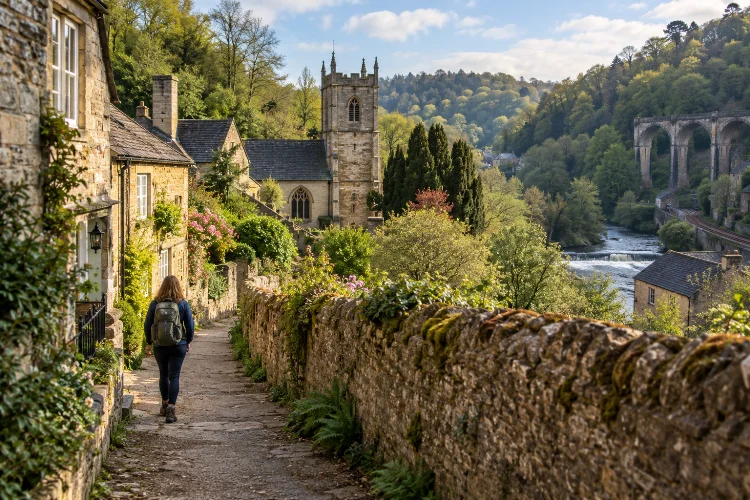
Limpley Stoke is one of those places that makes far more sense when explored slowly. From a car window, you notice a steep Wiltshire village, old stone buildings, wooded slopes, and the River Avon below.
On foot, however, the landscape begins to reveal how different centuries fit together.
Exploring Limpley Stoke on foot through historic valley routes can take you past a church with pre-Conquest origins, former weaving areas, historic bridges, nineteenth-century road engineering, railway infrastructure, and the nearby Kennet & Avon Canal.
Several of these features developed because the narrow Avon Valley repeatedly attracted people looking for water power, transport links, and routes between Bath and the countryside farther east.
The best approach is not necessarily to follow one long trail from start to finish. Instead, combine established footpaths and nearby walking routes around Limpley Stoke, Freshford, Dundas, and Avoncliff.
Do that, and a pleasant countryside walk becomes something more interesting: a journey through the changing geography of a historic valley.
Start Around St Mary’s and the Oldest Part of Limpley Stoke
A natural place to begin is the Church of St Mary on Church Lane.
Historic England dates parts of the Grade II* church to the tenth century, with additions from the early thirteenth and fifteenth centuries and later restoration work. That makes it one of the clearest physical links with Limpley Stoke’s early settlement history.
Wiltshire’s community history records that the original Saxon settlement, once known as Hanging Stoke, stood east and south of the present church. The community was severely affected by the Black Death in 1348–49, and later settlement expanded farther north.
Walking here gives you something that maps alone cannot provide. The church sits above the lower valley, so you can immediately understand how elevation, river access, and later movement through the landscape influenced village growth.
Look beyond the church itself. The lanes, stone boundaries, slopes, and gaps between older buildings are all part of the historical picture.
Follow the Two Church Route Toward Freshford
One of the most practical ways to connect Limpley Stoke with the surrounding valley is the Two Church Circular, an official Cotswolds National Landscape walk linking St Mary’s with St Peter’s Church in Freshford.
The circular is about 2 miles, or 3.22 kilometres, and usually takes around an hour. It includes approximately 95 metres of ascent and descent, so the short distance should not be mistaken for a completely flat stroll.
The route passes Crowe Lane and Crowe Hill, where walkers can look back across the Limpley Stoke Valley. It also crosses fields and wooded sections before reaching Freshford.
This is an especially good route for first-time visitors because it combines village architecture with countryside rather than focusing entirely on one or the other.
Some sections are unsurfaced, and the official guidance warns that the steep path can become muddy after rain. Sturdy shoes are therefore a better choice than casual city footwear.
Notice How Middle Stoke Reveals the Village’s Industrial Past
As you move through the settlement, Middle Stoke deserves more attention than its quiet appearance might suggest.
After the medieval population decline, a new community developed farther north during the fifteenth century. Wiltshire’s historical record links this growth directly to cloth weaving and the use of river-powered fulling mills.
By around 1500, workers’ cottages had appeared, while businesses such as an inn, bakery, and cider house developed around the new settlement centre.
That history makes walking through Middle Stoke different once you know what to look for.
The houses are not simply picturesque limestone cottages. They belong to a settlement pattern influenced by employment, water power, and textile manufacturing.
Nearby Limpley Stoke Mill was being used for fulling woollen cloth by 1376. By 1816, a later factory on the site employed about 200 people, showing how substantial local textile production eventually became.
The peaceful village streets therefore hide a much busier industral past.
Descend Toward the Avon and the Old Transport Corridor
The lower valley reveals another stage in Limpley Stoke’s history.
River, road, railway, and canal all occupy the same narrow corridor. That concentration is not accidental. The Avon Valley provided one of the easiest natural routes through a landscape otherwise broken by hills and steep slopes.
The historic road network is represented dramatically by Limpley Stoke Viaduct. Built in 1834, the Grade II listed structure carries the Bath-to-Warminster road across the valley on eleven tall round-headed arches.
The railway followed later. Wiltshire’s history records that the line through Limpley Stoke opened in 1857, linking Bathampton and Trowbridge, with a second track added in the 1880s. The local station eventually closed in 1966.
Walking through this area makes the engineering easier to understand. Instead of seeing each structure seperated from the others, you can see how generations repeatedly reused the same valley corridor.
Detour Toward Stokeford Bridge
Historic bridges are easy to overlook when they still perform an everyday function.
Stokeford Bridge, also known as Limpley Stoke Bridge, is protected as a Scheduled Monument. Historic England notes that the multi-span bridge retains important historic fabric despite later alterations.
Bridges mattered enormously in a river valley. Before modern roads, a dependable crossing could determine how people reached neighbouring settlements, transported goods, attended markets, or moved livestock.
Including a bridge in a historical walk therefore adds more than a photogenic stopping point.
It encourages you to think about movement before railways and modern highways existed. The River Avon was both an economic resource and a physical obstacle, so crossings became essential pieces of local infrastructure.
Take a little time here rather than simply passing through. Old bridge masonry often makes more sense when viewed from different angles along the riverbank.
Join the Kennet & Avon Canal Near Dundas
One of the finest extensions from Limpley Stoke is the Kennet & Avon Canal.
Strictly speaking, the canal and Dundas Aqueduct lie outside the modern civil parish of Limpley Stoke, despite being closely associated with the village landscape.
Bradford on Avon Museum specifically notes that no part of the Kennet & Avon Canal or Dundas Aqueduct falls within the parish boundary.
For walkers, however, the distinction matters far less than the geography.
The canal reached the valley in the early nineteenth century, adding another transport layer alongside the river and roads. Today, the towpath creates one of the easiest ways to experience the wider Avon Valley.
Cotswolds National Landscape describes a 6.5-mile return walk from Brassknocker Basin to Avoncliff as an easy, scenic route passing two aqueducts. The surface can be stony and uneven, but there are no road crossings on the published route.
It is an excellent contrast to Limpley Stoke’s steeper lanes.
Walk From Freshford Toward Avoncliff
For a longer extension, continue through the valley toward Avoncliff.
Visit Bath recommends Freshford as a starting point for scenic walks beside the River Avon toward Avoncliff, where walkers can connect with the Kennet & Avon Canal via the aqueduct.
This stretch feels more openly rural than the village lanes.
Woodland, fields, riverbanks, railway glimpses, and steep valley sides create constantly changing scenary. Once you reach Avoncliff, the aqueduct becomes the obvious landmark.
From there, you have several choices. Follow the canal east toward Bradford-on-Avon, turn west toward Dundas and Bath, or use the railway to create a linear walk rather than retracing the entire route.
Visit Bath specifically highlights Freshford and Avoncliff stations as useful access points for countryside walking.
This flexibility makes the valley unusually accessable without a car.
Read the Landscape Rather Than Chasing Distance
The most rewarding Limpley Stoke walk is not necessarily the longest.
This is a place where short distances contain several historical layers. Within a relatively small area you can move from a Saxon church site to medieval settlement patterns, a textile landscape, Georgian canal engineering, Victorian railways, and nineteenth-century road infrastructure.
The trick is to slow down.
Notice where houses cluster. Look at the relationship between cottages and former employment areas. Compare the high village lanes with the flatter transport routes below.
The shape of the valley explains much of what you see.
People built close to water when mills mattered, crossed the Avon where engineering allowed it, and later squeezed roads, railways, and canals into the most practical corridor available.
Once you begin looking for those relationships, even an ordinary stretch of lane starts to feel historically meaningful.
Practical Tips for Exploring Limpley Stoke on Foot
Footwear matters more here than distance.
The official Two Church Circular includes unsurfaced paths, steps, slopes, and sections that can become muddy in wet weather. The River Frome near Freshford is also noted as prone to flooding after heavy rain.
For longer walks, combining footpaths with the canal towpath provides a useful balance. Hillside routes offer broader views, while the canal delivers easier gradients.
Public transport can simplify planning too. Freshford and Avoncliff are connected by rail with Bath and Bradford-on-Avon, allowing walkers to build one-way routes rather than always returning to their starting point.
Most importantly, use a current walking or rights-of-way map before improvising detours. Historic-looking tracks are not automatically public footpaths, and conditions can change seasonally.
Exploring Limpley Stoke on foot through historic valley routes reveals far more than a pretty Wiltshire village.
Walking connects the landscape’s separate historical chapters: St Mary’s recalls the earliest settlement, Middle Stoke reflects the cloth economy, the Avon explains centuries of industry, and the viaduct, railway, canal, and aqueducts show how transportation transformed the valley.
For a short introduction, the Two Church Circular offers an excellent mix of heritage and views. For something longer, continue through Freshford or join the canal toward Dundas and Avoncliff.
Whichever route you choose, resist the temptation to rush. Stop at the old buildings, look across the valley, and pay attention to how each route follows the terrain. Limpley Stoke becomes much more interesting when its history is discovered one footstep at a time.
