

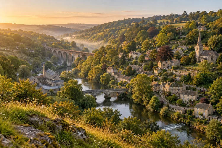
Tucked into the steep Avon Valley near the Somerset–Wiltshire border, Limpley Stoke is the kind of English village where history is not confined to a museum.
It appears in old stone walls, narrow lanes, river crossings, former industrial sites, churches, railway structures, and houses climbing the wooded slopes.
Exploring Limpley Stoke’s historic landscape reveals a place that has repeatedly adapted to changes in transport, industry, settlement, and everyday life.
Evidence of Roman activity survives around the area, while the medieval village was reshaped by population loss and the growing woollen trade.
Centuries later, turnpike improvements, railways, quarrying, and Victorian expansion left another layer on the valley. What makes Limpley Stoke especially interesting is how closely these periods overlap.
A walk through the village can move from an ancient church to former weaving areas, Georgian architecture, railway remains, and a nineteenth-century road viaduct in a remarkably short distance. The landscape essentially works as an open-air timeline.
A Landscape Shaped by the Avon Valley
Long before modern Limpley Stoke developed, its physical setting influenced where people could live and work. The village lies on rising ground beside the River Avon, with woodland occupying parts of the higher slopes and transport routes following the valley below.
That geography explains much of the settlement’s later history. Water supplied power for mills, the valley created a practical corridor for roads and railways, and the surrounding slopes offered stone, farmland, woodland, and defensible settlement sites.
The result is a village that feels vertically layered. Lower Stoke sits closer to the river and transport corridor, while other parts of the community rise above it.
Even today, looking across the valley helps explain why buildings, roads, industrial sites, and rail infrastructure developed where they did.
Interestingly, the nearby Kennet and Avon Canal is often visually associated with Limpley Stoke, although the canal itself does not actually lie within the modern civil parish.
Roman Activity and the Earliest Settlement
The history of Limpley Stoke stretches considerably further back than its surviving medieval buildings suggest.
Archaeological evidence indicates Roman activity around the area. Wiltshire’s community history records evidence of a Roman road linking Bath with places farther south through Frome and Wincanton.
Remains associated with Roman settlement have also been identified near Midford Lane and in ground close to the later church.
This makes geographical sense. Roman Bath was an important regional centre, and routes through the Avon Valley would have connected settlements, agricultural estates, and wider trading networks.
There is no surviving Roman townscape to wander through today, of course. Instead, the Roman story sits underneath later layers of developement.
That hidden archaeology is an important reminder that the modern village represents only the latest chapter of a much older occupied landscape.
Saxon Limpley Stoke and the Medieval Village
The original settlement was once known as Hanging Stoke, with documentary references appearing in the medieval period.
The name Limpley Stoke itself is recorded later, in the late sixteenth century. The element “Stoke” derives from Old English stoc, a word associated with a place or settlement.
A major surviving link with this early landscape is the Church of St Mary. Historic England dates elements of the building to the tenth century, with substantial additions from the thirteenth and fifteenth centuries. The church is now Grade II* listed.
Inside and around the building, architectural details preserve several periods rather than one neat construction date. A Saxon arch survives alongside later medieval work, while subsequent restorations added further layers.
The village’s medieval history was not peaceful continuity, however. Local historical records describe the Black Death of 1348-49 as devastating the original settlement. Population decline was severe enough that the later village effectively developed on a different pattern.
Cloth, Mills, and the Growth of Middle Stoke
One of the biggest transformations came from woollen cloth production.
Water was crucial to the industry because fulling – the cleaning and finishing of woven wool cloth – could be mechanised using water power. Records indicate that Limpley Stoke Mill was involved in fulling by 1376 and was still being used for the process in the early seventeenth century.
By around 1500, textile-related employment had helped establish a new centre of settlement. Weavers’ cottages appeared, and businesses serving the growing community followed. This gradually helped create what became known as Middle Stoke.
Industrial activity later became much larger. Between 1796 and 1822, the mill was operated by Bush, Newton & Bush, whose factory reportedly employed around 200 people in 1816.
That number provides useful perspective. Limpley Stoke may look like a quiet rural village now, but its landscape once supported significant industral activity.
Georgian Roads and the Limpley Stoke Viaduct
By the eighteenth and early nineteenth centuries, improved roads were reshaping connections between Bath, Warminster, Southampton, and surrounding communities.
One of the most dramatic reminders of this period is Limpley Stoke Viaduct. Built in 1834 as part of improvements to the Bath-Warminster road, it consists of eleven tall round-headed stone arches.
Historic England describes the structure as a Grade II listed viaduct and records that it was reinforced with concrete in 1920.
The viaduct demonstrates how engineering altered the historic valley without completely erasing its rural character. Rather than avoiding difficult terrain, nineteenth-century road builders increasingly imposed ambitious structures across it.
Nearby Georgian and early nineteenth-century houses add another dimension. Chatleigh House, for example, dates from around 1830, while Weir House is also protected for its architectural and historic interest.
Together, these buildings show a period when the valley was becoming better connected to prosperous neigbouring Bath.
Railways Changed the Valley Again
The arrival of the railway produced another major change.
Limpley Stoke station opened in 1857 when the Bradford-to-Bathampton railway connection was completed. The station served passengers but also supported local commerce, including the transport of building stone from nearby quarries.
Its role expanded in 1910 when Limpley Stoke became a junction for the Camerton branch. Coal from the Somerset Coalfield became an important part of traffic on this route, although passenger use on the branch remained limited.
Passenger services at the main station ended in 1966, but the building survives. The former branch also gained an unexpected cultural legacy: sections were used during filming of the 1953 Ealing comedy The Titfield Thunderbolt.
For visitors interested in railway history, this layer is particularly fascinating because the river, road and railway remain physically close together, showing how successive generations used essentially the same natural corridor.
Victorian Limpley Stoke and a Changing Village
By the Victorian period, Limpley Stoke had become more than an agricultural and textile settlement.
An 1870s gazetteer described a village surrounded by woods and orchards, with views across the river, canal and railway running through the valley at different levels. It recorded a population of 985 in 1861 and 218 houses.
This was a landscape where older industries mixed with newer institutions and transport systems. Textile manufacturing was declining, yet the railway increased mobility and made travel to Bath and other settlements easier.
The old mill also continued to find new purposes after traditional cloth manufacturing weakened. Such changes are typical of historic English industrial landscapes: buildings rarely remained dedicated to one use forever.
Instead, they were adapted, extended, abandoned, reused, or converted as the local economy evolved.
Reading Limpley Stoke’s Heritage Today
Modern visitors do not need an archaeology degree to recognise the village’s historical layers.
Start with the Church of St Mary, then pay attention to the relationship between Church Lane, Middle Stoke, Lower Stoke, the river and old transport routes. Listed houses, walls, bridges and surviving railway features gradually reveal how the community expanded and shifted over time.
The civil parish contains numerous listed structures, including cottages, houses, the former Baptist chapel, monuments, the viaduct and other historic features. Stokeford Bridge is additionally protected as a scheduled monument.
The key is not to view each building in isolation. A mill makes more sense when connected to the river. A workers’ cottage makes more sense beside the history of textiles. The railway becomes clearer when you understand quarrying and coal traffic.
Walking slowly and observing these relationships turns seemingly ordinary scenery into a historical map.
Exploring Limpley Stoke’s historic landscape is really about discovering how one small Avon Valley community responded to more than a thousand years of change.
Roman routes, Saxon settlement, medieval religion, the Black Death, woollen manufacturing, Georgian road building and Victorian railways all contributed to the village visible today.
What makes the area special is that these histories were never completely seperated. They sit beside and sometimes directly on top of one another, creating a landscape where geography and human activity remain closely connected.
If you visit Limpley Stoke, avoid simply driving through on the way to Bath or Bradford on Avon.
Walk the lanes, study the stone buildings, look across the valley and follow the old transport corridors. The village becomes far more interesting once you learn to read the history hidden in its landscape.
